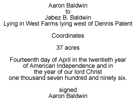
![]()
|
| Vailsburg | |||
|
|
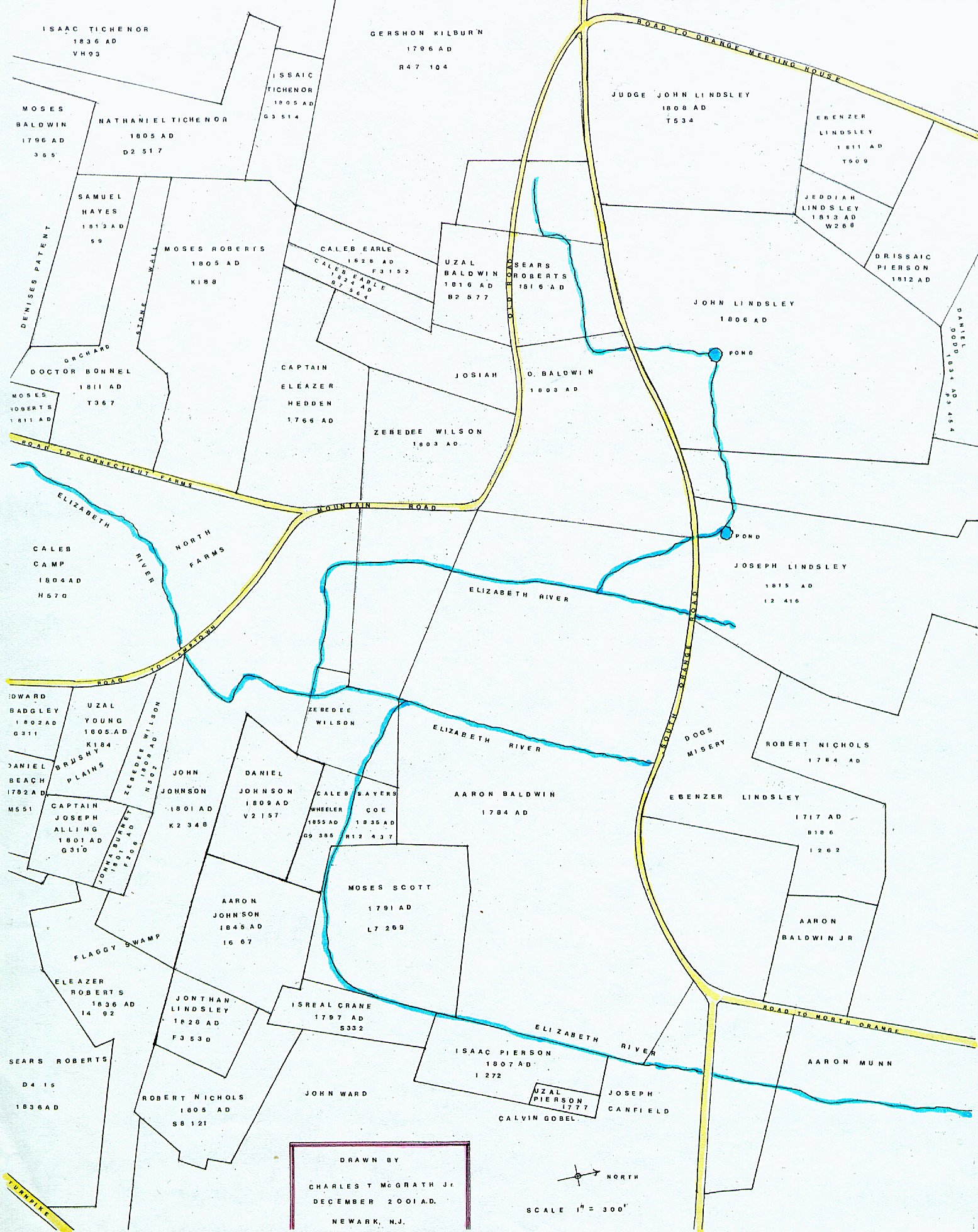
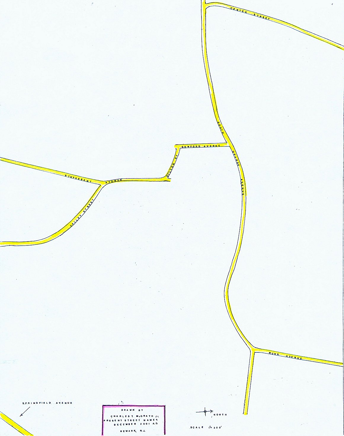
The map linked above were created by Charles McGrath, this is his explanation of how he created them: The attached are two maps of the area of Newark called Vailsburg. The detailed map is what it looked like in the 1700's and early 1800's. The other map is for cross reference and shows what the former roads as they presently exist. The area portrayed on both maps is approximately from South Orange east to the Garden State Parkway and from South Orange Avenue south to Springfield Avenue (this area is approximately two square miles). Long forgotten roads like "Old Road" and forgotten areas like Flaggy Swamp, Brushy Plain, Dogs Misery and North Farms (part of Camp Farms) can be seen on the detailed map. I began doing research on the history of Vailsburg in the early 1960's. At that time there were no complete maps of Vailsburg from the 1700's and early 1800's I tried to fill this void by generating a map of Vailsburg from that period. The description of land on a deed would contain coordinates, landmarks and the names of adjacent neighbors. Through extensive research of land deeds at the Essex County Hall of Records I became very familiar with its residents. This was essential because there were no street names or house numbers. The map was created like someone trying to solve a jigsaw puzzle. The main difference being that the puzzle pieces also had to be made. I would make a jigsaw piece from a known deed to a common scale of 1" = 300'. This piece would be compared with countless others to find it's location on the map. As a result, after many years of research, I developed a map of Vailsburg which reflects the area from the 1700's to the early 1800's. Each parcel of land on this map has the following information: The name on the property is that of the grantor (owner) who sold the
land to the grantee (buyer). The above mentioned information was obtained from the Grantor Books at the Essex County Hall of Records. For an example look at the upper left hand portion of the Vailsburg map. The property with road frontage on the west side of the Road to Connecticut Farms (Stuyvesant Avenue) was sold by Doctor Bonnel to Jabez Baldwin in 1811 A.D. In Grantor's Book T, located on page 367. The following is a description of that parcel of land on this map as copied from the deed: On the northwest side of the road that leads from Captain Eleazer Hedden's to Connecticut Farms. Beginning at the southeast corner of Jonathan Lindsley's orchard at a white oak stump. (1) N68 Degrees W 17 chains and 4 links to Nathaniel Tichenor's. (2) S14 Degrees W 3 chains to a stake. (3) S65 Degrees E 17 chains and 78 links to the end of a stone fence. (4) S11 Degrees W 6 chains and 57 links to Denises Gutter. (5) S44 Degrees E 3 chains and 90 links to a stake at the corner of Moses Roberts. (6) N23 Degrees E 5 chains. (7) S68 Degrees E 6 chains and 86 links. (8) N27 Degrees E 7 chains and 27 links. (9) S78 Degrees E 1 chain. (10) N26 Degrees E 1 chain and 19 links. (11) N83 Degrees W 70 links. (12) N21 Degrees W 2 chains. (13) N5 Degrees E 1 chain and 54 links . (14) N63 Degrees W 2 chains and 54 links. (15) N78 Degrees W 2 chains and 79 links. (16) N62 Degrees W 2 chains and 52 links. (17) N82 Degrees W 2 chains and 78 links. (18) S25 Degrees W 2 chains and 33 links to the beginning. (total area = 19 acres) Note One chain equals 100 links or 66 feet
|
||
| Copyright 1998 - 2026 Glenn G. Geisheimer |